Geography
Geography
Published 2002
Fulfilling formal prayers and Pilgrimage duties, Muslims needed to find the direction and routes leading to al Ka’ba from virtually any spot on the globe. Ka’ba, the house of Abraham in Mecca, is what Muslims face when they perform prayers. This is known as “Qibla.” To find Qibla from any part of the globe, Muslims invented the compass and developed the sciences of geography and geometry.
Geography in Sicily
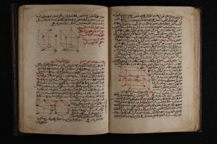
Abu Abdulla al-Idrisi: (1000-1166) He was born in Ceuta, but received his education in Cordoba. After visiting Spain, North Africa, and Asia Minor he settled in Sicily. He was the greatest geographer of the Middle Ages. For King of Sicily, Roger II (1130-1154) he made a celestial globe and a disk shape map in silver showing seven zones of the world. He was commissioned by the King to write the geography of the world. This work is entitled Nuzhat al-Mushtaq fee Ikhtiraq al-Afaq(or Kitab al-Rujjar, a book of Roger). It was illustrated with 70 maps. He did his work at Palermo, the aforementioned book shows his grasp of such fundamental facts as sphericity of the earth. This doctrine was crucial to the discovery of America. A synopsis of the text with 71 maps was printed in Rome in 1592. Partial editions of the text have been made in Leyden, Rome, and Bonn.

Pilgrimage’s duty to Mecca, which Muslims must make at least once in his or their lifetime, is directly responsible for developing the science of geography. Muslims from as far as Malaysia and Indonesia, from Europe and Africa, found their ways to Mecca. Arab pilots and the wealth of geographical maps and books developed from the 7th century to the 15th century were the engines from which the European discoveries of the 15th century were made.

Ibn Battutah (Batutah), b 24 February 1304 in Tangier, d 1368 in Fès, was an Arab traveler and merchant. From 1325 to 1353, he visited many countries of Europe, Asia, and Africa, including the southern regions of present-day Ukraine. Ibn Battutah’s 14th-century masterpieces provided a detailed view of the geography of the ancient world.
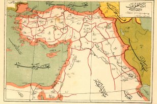
This is a map of the world made by the Muslim geographer Jihani in the 10th century of the Christian era. The names have been translated from Arabic. Many Muslim civilizations have been seafaring and relied heavily on maps. For that reason, Muslim societies also studied astronomy intensely and invented the modern naval sextant.
Recommended Posts
Women’s Rights to Own Property
January 20, 2018
Navigation
January 20, 2018
Algebra
July 4, 2017